The Death of Landmark Beach: What the consequences mean to tourists, the economy, and the environment
"why destroy the livelihoods of many with an unplanned and unassessed project"
"why destroy the livelihoods of many with an unplanned and unassessed project"
It has been four months since the Lagos Controller of Works, Olukorede Kesha, promised to compensate businesses affected by the Landmark Beach demolitions from a N2.7 billion fund. So far, only two brick buildings have been compensated – the restaurant Island Breeze and the Lagos Breeze Beach Club. Kesha had promised to pay shanties on “compassionate grounds,” but this changed when the Federal Minister of Works, David Umahi, defended the Landmark demolition, stating explicitly that the government “does not pay for shanties,” as they are located on the highway’s Right-of-Way.
With Landmark Beach still fighting for N42 billion worth of compensation and shanties being destroyed without pay, it is safe to say that the fate of Landmark Beach is as bleak as ever, with the livelihoods of traders being destroyed, and the Managing Director, Paul Onwuanibe setting his eyes on new horizons beyond Nigeria instead.
But Onwuanibe and the traders aren’t the only ones bearing the consequences. There is much more at stake – from tourism, to the local economy, and of course, the environment. But to understand the ramifications, we need to first understand the importance of Landmark Beach to Nigerian society.
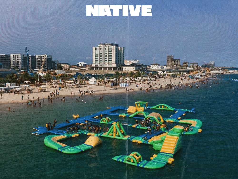
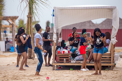
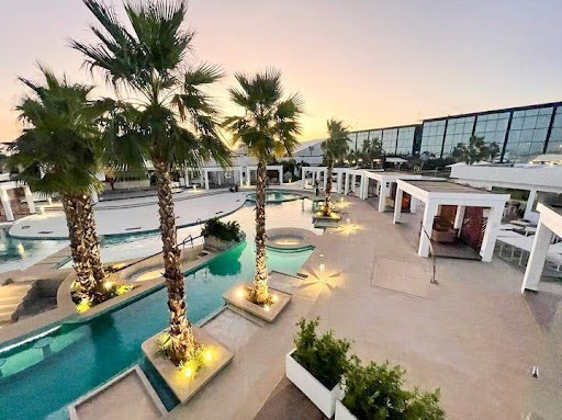
Before 2024, Landmark Beach – a popular tourist destination in Lagos known for its beauty, exorbitant fees, and concerts featuring A-list musicians – was a picturesque escape from the bustling city of Lagos. With its pristine sandy shores, turquoise waters and a panoramic view of the Atlantic Ocean, it was the perfect place for tourists – and the locals who could afford it – to enjoy a weekend of lively music, slightly overpriced but delicious food, and paintball activities with family, friends or even by themselves.
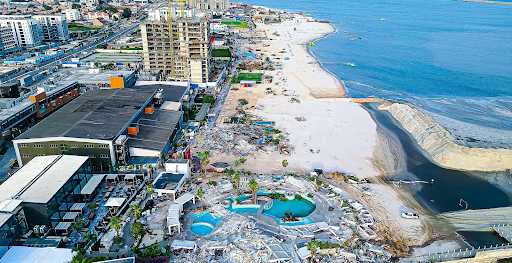
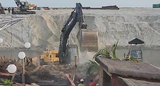
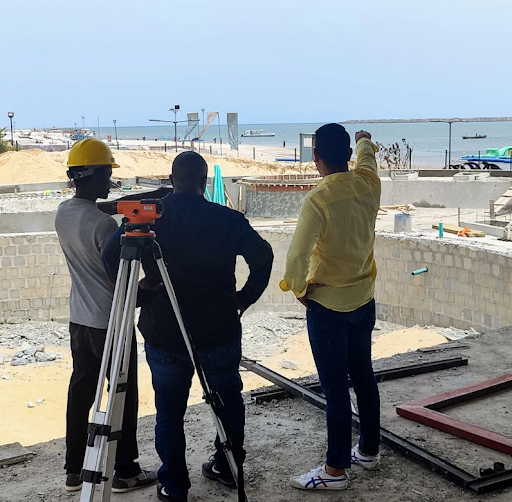
Today, the carefree spirit of Landmark Beach has been ruthlessly silenced. Where joyous melodies once danced with the waves, an unsettling quiet now reigns. Bulldozers have devoured the remnants of hurriedly dismantled structures, leaving behind a desolate landscape. Offshore, you can hear monstrous dredging vessels churn in the water, turning its once inviting turquoise into a murky, frothy brown. The once-iconic beach is now a mere ghost of its former self, a hollow shell whispering tales of a vibrant past.
For over 17 years, Landmark Beach reigned as Lagos’s premier private beachfront destination. A hive of entrepreneurial activity, it buzzed with over 40 businesses offering a kaleidoscope of leisure options, estimated to be worth over ₦20 billion.
But Landmark Beach wasn’t just fun; it was also a well-oiled machine. ₦25 billion had been spent on infrastructure, creating a solid foundation for success. Onwuanibe has proudly highlighted the beach’s economic impact – over 12,000 jobs were created and a staggering 3.5 million tourists flocked there annually. Revenue figures mirrored this success, with Landmark raking in at least ₦2 billion ($1.5 million) every year.
Then, on April 24, 2024, a seven-day eviction notice and demolition warning from the Lagos State Government landed like a bombshell on Onwuanibe’s desk. Two days later, a meeting with the Federal Ministry of Works offered a mix of clarity and harsh reality for Landmark’s businesses.
The reason for the demolition, the government said, was the upcoming Lagos-Calabar coastal road project, a highway designed to be a ‘scenic route’ similar to coastal highways in other countries.
According to Onwuanibe, the original plans for the Lagos-Calabar coastal highway designated a 1.5km stretch along the Water Corporation Road median as the right-of-way. However, Umahi opted against this initial alignment, citing the area’s significant development with high-rise buildings and costly infrastructure, and the need for a revised design to reroute the coastal highway and accommodate these new structures.
In March, Umahi announced that the coastal highway – an idea first conceptualised in 1955 by then Federal Commissioner of Finance, Festus Okotie-Eboh – was to commence in April and to be completed within eight years, which aligns with a two-term tenure for current president Bola Tinubu.
The first phase of this would be constructing 47.7km of highway from Ahmadu Bello Way, Victoria Island, all the way to the Lekki Deep Sea Port within Lagos State. In the initial plan, the Water Corporation Road itself was to be part of the coastal highway, but that was changed to include the coastal shorelines, including Landmark Beach.
There was no pertinent reason as to “why,” but despite Onwuanibe’s disagreement with the plan, Umahi insisted that only 50 metres of the shoreline would be used, and said the decision was “irrevocable.”
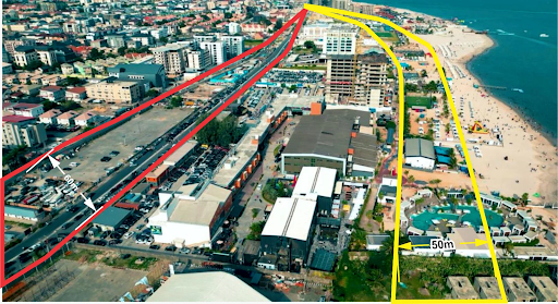
Business structures within the first three kilometers of the newly-designated right-of-way needed to be cleared out immediately. The news sent shockwaves through not just Landmark, but also neighboring beaches like Oniru, The Good Beach, and Sol Beach, all nestled within the close 1.4-kilometer stretch.
“In less than three hours, my dreams were destroyed”
When it came to perfect wedding destinations, Onyinyechi Achigbu, a communications specialist, always had Landmark Beach in mind. She and her partner of three years had made it a hobby to visit the beach at least once a month because of the lively atmosphere and close proximity to their home on the island.

On the verge of tears, Onyinye explained to NATIVE just how much the beach means to her. “There was this running joke my partner and I had that if we got married, our wedding guests must be clad in nothing more than shorts and swimsuits because the venue would be at Landmark Beach. It had become a place of peace and escapism for us.” Now, Onyinye has to settle for other beaches like Leisure beach, which is located in Lekki and which she complained was “too quiet for her tastes.”
While tourists may have only an emotional response, the after effect for entrepreneurs also has a financial overlay to it. Awni Berry, an Indian expatriate and General Manager for now-demolished Breeze Beach Club, disclosed to NATIVE that he was offered N100 million as compensation by the government, which is nowhere near the value of construction, a whopping N500 million.
“For the past four years, I put my blood, sweat and tears into making this club a premium luxury relaxation spot. Now, I have to refund $4500 to nearly one? hundred subscribers in less than a month. I got government compensation yes, but can they repay all the running costs acquired in my four years of running this business? Absolutely not!” he angrily lamented. For now, Lagos Breeze Beach Club is closed until further notice.
Deji Akinjobi, a lawyer and investor in the Honey Night Club Lounge, a segment of the Mami Chula luxury resort on Oniru Beach, was only a new investment partner in the club as at February 2024. He has been making plans to relocate from Nigeria with help fromthe club’s earnings, but those plans have now ground to a halt with the demolitions.
With a mixture of both anger and sadness, he said “words can’t begin to describe what I feel. I invested N40 million in Honey Club because I thought I could cash out from it and start life afresh in Canada. But the government came in and did its worst. It’s funny how you save all your pennies and get your dreams destroyed in less than three hours.”
Still, it’s the businesses classified as shanties who have taken the most hits, as they are deemed ineligible for compensation. *Betty, a single mother of three who used to sell a variety of finger foods popularly known as “small chops” out of a metal container at Oniru Beach, now sits with a gloomy look on her face as she watches the structures around her being destroyed. She refused to have her photo taken for NATIVE, but she disclosed how she made nearly N150,000 every week from sales.
“It’s hard for me because most of these new beaches don’t allow people like me to set up business anyhow. I have to start going to both Lagos State office and the beach for registration and build a proper structure. My kids are in secondary school and I am already owing a term’s school fees. This has set me back to square one,” she complained.
Despite a federal law restricting construction within 100 meters of rivers and 250 meters of shorelines to protect waterways, lack of enforcement has allowed developments to creep closer and closer to the Victoria Island beachfront over the years. This meant that while some occupants filed taxes, they had no valid claim over those spaces beyond largely undocumented approvals.
As a result, once the evacuation order was made, many entrepreneurs were asked to prove the value of their structures on the spot. Some fetched supporting documents, while others made panicked calls to their managers, and questioned the idea of valuing businesses by metrics that neglected losses incurred in irreversible financial obligations like bills or bank loans.
Since the Lagos-Calabar coastal highway was announced, there have been concerns about whether or not an Environmental and Social Impact Assessment (ESIA) was completed before construction began.
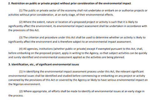
The EIA Act of 1992 mandates that such an assessment be conducted and approved by the Federal Ministry of Environment before any major project commences. This requirement aims to mitigate potential environmental and social disruptions caused by large-scale construction.
How does an EIA work?
The Environmental Impact Assessment (EIA) process is a critical step in ensuring environmentally responsible development. Here’s a breakdown of the key stages involved:
Scoping: This stage defines the environmental issues to be addressed in the EIA study. It helps identify the most significant environmental concerns associated with the project.
Baseline Studies: Data on various environmental aspects in the project area is gathered to establish a baseline. This data typically covers air quality, water quality, biodiversity, soil conditions, socio-economic factors, and other relevant aspects.
Impact Assessment Studies: The potential impacts of the project on the environment are evaluated. These studies consider both direct and indirect impacts, as well as cumulative effects over time.
Mitigation Measures: Plans are developed to minimize or offset any adverse environmental impacts identified during the assessment stage.
EIA Report Preparation: A comprehensive report is prepared that summarizes the findings of all the preceding stages. This report includes details on scoping, baseline studies, impact assessments, and proposed mitigation measures. The EIA report is submitted for review and approval before project commencement.
In speaking with Professor Ademola Omojola, a geography and remote sensing expert, he said that projects undertaken outside of “green zones” (areas with no significant human activity) must have a report with an additional social impact component which is to identify potential social disruptions to be caused by the project and the decisions to be made to mitigate these disruptions.
Now, here’s the controversial part: Umahi failed to confirm the existence of an ESIA when asked. A letter from Kesha had also been sent to residents in certain areas along the highway, asking them to attend a workshop after the implementation of the project. The letter stated that this data collection was to ensure that the project is developed “responsibly and sustainably” and in line with local regulations and international standards. The move suggests that an ESIA, meant to be done in a project’s planning stages, was non-existent when implementation commenced.
“Conducting an impact assessment before project planning could have revealed alternative solutions that wouldn’t have required this demolition,” Adebiyi Momoh, a Lagos-based civil engineer, pointed out.
There is no doubt that the demolition of these beachfront properties has put a huge strain on tourism in Lagos. Landmark beach was a magnet for foreign visitors into the country who were looking for a place of relaxation. The demolition reduces tourism opportunities and severely impacts local businesses that depend on visitor traffic.
Still, the construction of the 753 km coastal highway will bring its own opportunities for economic growth. As seasoned economist, Asue Ighodalo, told NATIVE,the highway could also improve transportation infrastructure as well as boost trade.
“It would be a huge advantage to the people of the South-South, as it would enable them access and distribute trade goods from Lagos faster than before,” he said. “However, it is wrong for the government to sacrifice tourism for business priorities and destroy livelihoods.”
The 10-lane coastal highway has been designed to connect Lagos to Cross River, passing through the coastal states of Ogun, Ondo, Delta, Bayelsa, Rivers, and Akwa Ibom, before terminating in Cross River. HITECH construction firm, (notably owned by President Bola Tinubu’s long-time friend and business partner, Gilbert Chagoury) was contracted at ₦15 trillion or $9.6 billion per km.
The Eko Atlantic project, a massive land reclamation endeavor, sparked its own environmental concerns due to the absence of a pre-vetted ESIA report. With Lagos facing escalating annual flooding, expert predictions warn of a two-meter sea level rise by the end of the century, putting the city’s low-lying topography at risk of complete submersion.
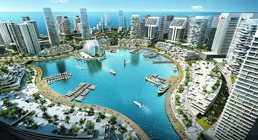
Launched in 2008, the project aims to reclaim 10 million square meters of ocean land in phases, constructing an ultra-modern city protected by an 8.5 km sea wall. While initially conceived as a solution to the perpetually overflowing Lagos Bar Beach, the project’s massive scale of ocean land reclamation has raised concerns about improperly diverting excess water, and possibly exacerbating flooding in nearby areas.
The project’s location on the former Bar Beach site has also raised concerns about the repurposing of beach fronts along the axis, resulting in the drainage of recreational water bodies at Oniru Private Beach, Landmark, The Good Beach, and Sol Beach in Victoria Island. Despite the Lagos State government’s enthusiasm for the project, its potential environmental impact has sparked widespread apprehension among citizens and experts.
As the Lagos-Calabar coastal highway, divided into sections, begins at Eko Atlantic’s Ahmadu Bello Road (0.0 km) and terminates at Ibeju Lekki (47.5 km), concerns about the project’s potential environmental footprint continue to grow.
Momoh, an engineer, continues to sound the alarm on the unchecked pace of land reclamation in Lagos, which imperils nearby structures. “The water displaced by sand-filling has to go somewhere, and it’s manifesting in Lekki’s frequent flooding during rainfall, a stark contrast to the past,” he observes.
Omojola highlights the alarming coastal erosion afflicting shorelines in Lagos, Ogun, and Ondo, cautioning that 80% of the stretch for the Lagos-Calabar highway will experience shoreline retreat, potentially culminating in a “catastrophe” if the project is not executed with due care. This concern is compounded by reports of flooding in the Niger Delta region due to coastal erosion.
While acknowledging the Eko Atlantic wall’s role as a buffer against beach recession in Lagos, Omojola stresses the need for comprehensive studies to determine its efficacy. He criticizes the haphazard approach to infrastructure development in Nigeria, citing examples of successful road constructions in countries with extensive coastal areas below sea level. Omojola also believes the coastal highway has the potential to revitalize tourism and spark a real estate boom in adjacent states like Ogun. He cites the example of Ode Omi, a community that should have flourished if not for lack of accessibility, and hopes that the road project would bring about positive transformation.
Landmark Beach Resort appears to be exploring new horizons, announcing on social media its intention to pursue investment opportunities outside of Lagos and Nigeria. Additionally, they are seeking monetary compensation from the government to revive businesses and livelihoods threatened by the demolition.
Official Press Statement from the Landmark Africa Group following the Demolition of the Landmark Beach, Current State of Business and Future Plans (Landmark 2.0). pic.twitter.com/MEnBfn0fOZ
— Landmark Africa (@landmarkafrica) May 23, 2024
A former governorship candidate of the Action Democratic Congress (ADC) in Lagos, Funsho Doherty, has also threatened to sue the Bureau of Public Procurement (BPP) due to their failure to uphold compliance with the Public Procurement Act of 2007 during the award process for the Lagos-Calabar coastal highway project, which enforces competition, efficiency, and affordability in project selection.
However, this does not seem to be a hindrance to the Federal Government’s coastal highway, as work on Sections 1(from Ahmadu Bello Way to Lekki Deep Sea Port) and 2 (Lekki Deep Sea Port to Lagos-Ogun border) of the highway has already commenced. The construction of Sections 3 and 4 (which cover Cross River state and Akwa Ibom) is set to be inaugurated by Tinubu in August.
However, a lingering question remains – why destroy the livelihoods of many with an unplanned and unassessed project?
Only Umahi can answer this.
Featured Image Credits/The NATIVE
